Loading...

A large amount of data is collected each year in the subprojects of the Biodiversity Exploratories (BE), reflecting the broad spectrum of scientific questions. It is essential to store these data centrally to ensure easy, fair and reproducible data sharing between the researchers. 

It is also crucial that these data are not lost and are available for future generations of researchers within the BE and as well as external projects. Long-time series are for many questions in biodiversity research of great interest.

To ensure this, the data management project, as one of the central infrastructure projects, has accompanied the BE from the beginning. It is located at the Friedrich Schiller University in Jena, Germany.
It is the first contact point for all aspects of research data management for all BE participants, other researchers, and the interested public.


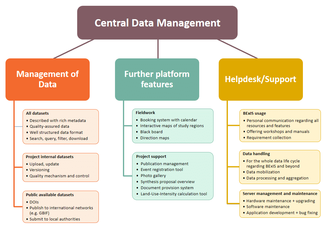
We achieve the main goals described above regarding the storage and exchange of the research data with a web application called BExIS. Below you will find sections with additional information on this. 

We support researchers in using BExIS and in all data management issues. We offer help in uploading data into BExIS and ensure high data quality (data curation). Last but not least, we advise and support researchers in publishing their data.

In addition to the research data support, we promote the exchange of important documents and publications in the overall project and offer software tools for querying basic data, such as climate data. Furthermore, we support the researchers by providing important information and tools for planning and conducting fieldwork in BExIS. These aspects are shown in the following figure and explained in more detail in the ‘Functionalities of BExIS section’.


BExIS is the abbreviation of our information system name ‘Biodiversity Exploratories Information System’. Initially, the software was developed and continuously extended in the BE project since 2007 (BExIS, 1st generation). Other research projects also showed interest in such an application. But it was not easy to set up BExIS for other projects, as it was developed for the demands of the BE. Hence, a DFG project was initiated in 2012 with the participation of our team. The goal was to develop a modular data management system for ecological data that can be easily adapted to the needs of different projects.

The new software was named BEXIS2 and is a freely available, server-based research data management application. It is designed to support the entire data life cycle and is highly configurable. Among other things, it supports the use of different metadata schemas, access to different versions of the data, predefinition of variables, rights assignment with an integrated release request and release management for datasets, search configuration, and DOI assignment.

In February 2021, the BE project started to use the BEXIS2 software. However, the name ‘BExIS’ continues to stand for the BE’s information system. Since the BExIS2 software is modular, we extended it with our BE-specific functionalities (see section ‘Functionalities of BExIS’) and made them available to other projects using BEXIS2.

If you are interested in the development of the platform, you can get an overview on the GitHub pages:

  • BEXIS2: the core data management software
  • BExIS: BE specific features, provided as BEXIS2 modules

For the current phase, various work packages have been proposed to guarantee the day-to-day operation of the research database and data management in general. The secure storage of data in a sustainable data management system requires the management of the research data and the support of the users, maintenance of the technology and software, and the further development of BEXIS2 and BE specific features.

Aspects of data mobilization and publication are also part of these work packages. Our work includes an active curation of the data together with the scientists to achieve a high quality of the metadata and the data and to be able to offer them FAIR to the public, also with a DOI.

In order to be able to continuously offer high data quality and to support the FAIR principles, we will continue to work on the software. We will implement functions that promote a high data quality and, in particular, support the work of a data curator.

A particular focus in this phase will be on enabling persistent identifier (PID) use and enriching and linking various internal resources with it. This information should be made available externally and linked to corresponding open services.

Furthermore, in this phase, we want to introduce data management plans (DMP) in the BEs. Based on available recommendations, we will create a concept and support the projects filling out the DMPs.


BEXIS2 mainly provides functions for handling data and managing registered persons. An overview of the core functions can be found on the BEXIS2 feature page.

In addition, we develop special functions tailored to the needs of the BE (see goals). Since we also follow the modular approach during programming, these modules are usable by other projects. An overview of existing BEXIS2 modules is provided on the BEXIS2 module page. Below you find a brief overview of our developed components.

Resource booking system

With this system, resources can be self-defined and administered in a calendar. We use it for the booking in the field stations of the study regions. The researchers can reserve sleeping places and equipment available in the stations. Furthermore, it shows planned work and affected areas .

Document upload system

This module is used to create web pages to manage documents in BEXIS2. On these pages, important and cross-project-related documents can be shared centrally. It is adjustable who can see the page and its files, who can upload files and also delete them again.

Event registration system

The system allows the management of registrations for own events. Details such as the required information for the events and the registration period can be configured individually. Participants receive an email after registration and can customize it later.

Photo gallery

Many photos are taken during fieldwork and events by the several projects. The photo gallery is a central place to store these photos and make them available to other researchers. The images are displayed in a preview and can be filtered by keywords. You can put pictures into a shopping cart to order them afterward.

Graphical research area management

With this system, it is possible to draw maps of the study areas using simple graphical shapes, such as circles, squares, and lines. These maps assist researchers in planning the various studies. It also documents all previous investigations.

Climate data embedding system

The data from the climate stations are managed in a separate application. With this module, the application is integrated seamlessly in BEXIS2.

Calculation of an important parameter of land-use

The so-called LUI (land-use intensity index) is a parameter that describes the management intensity of grassland. The calculation is based on different parameters of grassland management. With the help of this application, researchers can calculate the LUI specifically for the current question by selecting relevant years and areas.


Doc
Ontology- and graph-based approaches for the bibliometric analysis of scientific publications using the example of the Biodiversity Exploratories
Ontologie- und Graphenbasierte Ansätze zur bibliometrischen Analyse wissenschaftlicher Publikationen am Beispiel der Biodiversitäts-Exploratorien
Gänßinger M. (2024): Ontologie- und Graphenbasierte Ansätze zur bibliometrischen Analyse wissenschaftlicher Publikationen am Beispiel der Biodiversitäts-Exploratorien. Master thesis, University Jena
Doc
Automatisierung von Prozessen in Forschungsdatenbanken: Entwicklung von Funktionen zum automatischen Ausfüllen von Metadatenschemas in BEXIS2
Ashfaq H. (2023): Automatisierung von Prozessen in Forschungsdatenbanken: Entwicklung von Funktionen zum automatischen Ausfüllen von Metadatenschemas in BEXIS2. Bachelor thesis. Friedrich-Schiller-University Jena
Doc
Berechnung und Visualisierung der Datenqualität von tabellarischen Daten im Datenmanagementsystem BEXIS2
Lamat M. (2022): Berechnung und Visualisierung der Datenqualität von tabellarischen Daten im Datenmanagementsystem BEXIS2. Bachelor thesis, University Jena
Doc
Domänenwissensbasierte Visualisierung Empfehlungssystem
Kaur P. (2021): Domain knowledge-based visualization recommendation system. Dissertation, University Jena
More information:  doi.org
Doc
Chamanara J., Gaikwad J., Gerlach R., Algergawy A., Ostrowski A., König-Ries B. (2021): BEXIS2: A FAIR-aligned data management system for biodiversity, ecology and environmental data. Biodiversity Data Journal 9: e72901. doi: 10.3897/BDJ.9.e72901
More information:  doi.org
Doc
Die Verschmelzung von automatischer Bild- und Bildunterschrift-Analyse zur Bestimmung von Diagrammtypen in Biodiversitätstexten
Kaur P., Kiesel D. (2020): Combining Image and Caption Analysis for Classifying Charts in Biodiversity Texts. Proceedings of the 15th International Joint Conference on Computer Vision, Imaging and Computer Graphics Theory and Applications 3: 157-168. doi: 10.5220/0008946701570168
More information:  doi.org
Doc
Löffler F., Abdelmageed N., Babalou S., Kaur P., König-Ries B. (2020): Tag Me If You Can! Semantic Annotation ofBiodiversity Metadata with the QEMP Corpus and the BiodivTagger. Proceedings of the 12th Conference on Language Resources and Evaluation (LREC 2020), p. 4557–4564
More information:  www.aclweb.org
Doc
Jänicke S., Kaur P., Kuzmicki P., Schmidt J. (2020): Participatory Visualization Design as an Approach to Minimize the Gap between Research and Application. "Eurovis workshop VISGAP: - The Gap between Visualization Research and Visualization Software". doi: 10.2312/visgap.20201108
More information:  doi.org
Doc
Schneider F. D., Fichtmüller D., Gossner M. M., Güntsch A., Jochum M., König-Ries B., Le Provost G., Manning P., Ostrowski A., Penone C., Simons N. K. (2019): Towards an Ecological Trait-data Standard. Methods in Ecology and Evolution 10 (12), 2006-2019. doi: 10.1111/2041-210X.13288
More information:  doi.org
Doc
Renner S. C., Suarez-Rubio M., Kaiser S., Nieschulze J., Kalko E. K. V., Tschapka M., Jung K. (2018): Divergent response to forest structure of two mobile vertebrate groups. Forest Ecology and Management 415–416, 129-138. doi: 10.1016/j.foreco.2018.02.028
More information:  doi.org
Doc
Problematiken und Vorschläge für die Entwicklung eines unterstützenden Werkzeugs für die Visualisierung von Biodiversitätsdaten
Kaur P., Klan F., König-Ries B. (2018): Issues and Suggestions for the Development of Biodiversity Data Visualization Support Tool. EuroVis 2018, Brno, Czech Republic
More information:  doi.org
Doc
Visrepo: Ein zentraler und frei verfügbarer Datenspeicher als Wissensbasis für Visualisierungen
Kaur P., Ostrowski A. (2018): Visrepo: A Centralized and Open Source Visualization Repository and Knowledgebase. 2nd IEEE VIS 2018, Berlin
More information:  c4pgv.dbvis.de
Doc
Kaur P., Owonibi M. (2017): A Review on Visualization Recommendation Strategies. Conference Paper, IVAPP 2017, Portugal . doi: 10.5220/0006175002660273
More information:  doi.org
Doc
Amara J., Kaur P., Owonibi M., Bouaziz B. (2017): Convolutional Neural Network Based Chart Image Classification. Conference paper, 25th International Conference in Central Europe on Computer Graphics, Czech Republic
More information:  wscg.zcu.cz
Doc
Ostrowski A. (2017): Exploratorien zur funktionellen Biodiversitätsforschung –Ein DFG Schwerpunktprogramm. Landschaftspflege und Naturschutz in Thüringen 54 (2), 83-85
More information:  www.thueringen.de
Doc
Entwicklung eines allgemeingültigen Buchungssystems
Owonibi M., Petzold E., König-Ries B. (2016): Towards a Generic Resource Booking Management System. In "Innovations in Enterprise Information Systems Management and Engineering" Felderer, M., Piazolo, F., Ortner, W., Brehm, L., Hof, H.-J. (Eds.). Springer International Publishing, pp 73-81. doi: 10.1007/978-3-319-32799-0
More information:  doi.org
Doc
Erste Schritte zur Entwicklung eines Empfehlungssystems für Visualisierungen von Biodiversitätsdaten
Kaur P., Gaikwad J., König-Ries B. (2016): Towards recommending visualizations for biodiversity data. Biodiversity and Conservation 25 (9), 1801-1803. doi: 10.1007/s10531-016-1157-z
More information:  doi.org
Doc
Chamanara J., Owonibi M., Algergawy A., Gerlach R. (2015): An Extensible Conceptual Model for Tabular Scientific Datasets. International Symposium on Challenges for Designing and Using Datasets. June 21-26 2015, Brussels, Belgium
More information:  www.thinkmind.org
Doc
Entwicklung eines halbauto-matischen Systems zur Emp-fehlung von Visualisierungen für Biodiversitätsdaten
Kaur P., Owonibi M., Koenig-Ries B. (2015): Towards Visualization Recommendation-A Semi-Automated Domain-Specific Learning Approach. Grundlagen von Datenbanken 30-35.
More information:  ceur-ws.org
Doc
Vorschlag eines Ablaufplans zur Prüfung der Datenqualität von Biodiversitätsdaten innerhalb eines Datenverwaltungssystems
Owonibi M., Koenig-Ries B. (2014): A Quality Management Workflow Proposal for a Biodiversity Data Repository. In "Advances in Conceptual Modeling" Indulska M., Purao S. (Eds.). Springer International Publishing, 157-167. doi: 10.1007/978-3-319-12256-4_17
More information:  doi.org
Doc
Lotz T., Nieschulze J., Bendix J., Dobbermann M., König-Ries B. (2012): Diverse or uniform?—Intercomparison of two major German project databases for interdisciplinary collaborative functional biodiversity research. Ecological Informatics 8, 10–19. doi: 10.1016/j.ecoinf.2011.11.004
More information:  doi.org
Doc
Heimann D., Nieschulze J., König-Ries B. (2010): A flexible statistics web processing service - Added value for information systems for experiment data. Journal of Integrative Bioinformatics 7 (1), 140. doi: 10.2390/biecoll-jib-2010-140
Doc
Heimann D., König-Ries B., Nieschulze J., The Biodiversity Exploratories Information System - Towards a service-oriented Framework for knowledge-based Data and Tool Integration, Proceedings of the Data Management Workshop, University of Cologne, Germany
More information:  www.tr32db.uni-koeln.de
Doc
Heimann D., Nieschulze J., König-Ries B., A web service based approach for integrating statistics tools into an information system for experiment data, Proceedings of Informatik 2009 - The 39th annual conference of the Gesellschaft für Informatik e.V., Lübeck
More information:  subs.emis.de
Doc
Verknüpfung von Datensätzen mit Ontologien mittels struktureller und semantischer Registrierung
Wilhelm H.(2009): Verknüpfung von Datensätzen mit Ontologien mittels struktureller und semantischer Registrierung. Thesis, Max-Planck-Institute for Biogeochemistry Jena
Doc
Die Verwendung von Ontologien für die semantische Integration von Daten und Werkzeugen
Heimann D., Nieschulze J., König-Ries B., Die Verwendung von Ontologien für die semantische Integration von Daten und Werkzeugen, Proceedings of the 20th GI-Workshop on Foundations of Databases (Grundlagen von Datenbanken, GvD), Apolda, April 2008

Public Datasets

Dataset
Nieschulze, Jens; Ostrowski, Andreas (2023): Topographical parameters (slope, aspect, elevation) for all forest and grassland experimental plots (EP). Version 6. Biodiversity Exploratories Information System. Dataset. https://www.bexis.uni-jena.de/ddm/data/Showdata/31501?version=6
Dataset
Ostrowski, Andreas; Lorenzen, Katrin; Petzold, Eleonora; Schindler, Sirko (2023): Land-use intensity index (LUI) calculation tool of the Biodiversity Exploratories project for grassland survey data from three different regions in Germany since 2006. Version 4. Biodiversity Exploratories Information System. Dataset. https://www.bexis.uni-jena.de/ddm/data/Showdata/31514?version=4
Dataset
Lorenzen, Katrin; Vogt, Juliane; Teuscher, Miriam; Ostrowski, Andreas; Thiele, Jan (2023): Input data of all grassland plots for Land-Use Intensity Index (LUI) calculation tool since 2006 - revised 2023. Version 7. Biodiversity Exploratories Information System. Dataset. https://www.bexis.uni-jena.de/ddm/data/Showdata/31661?version=7
Dataset
Memmert, Jörg; Magdon, Paul; Ostrowski, Andreas (2022): Borders of all three regions of the Biodiversity Exploratories project. Version 15. Biodiversity Exploratories Information System. Dataset. https://www.bexis.uni-jena.de/ddm/data/Showdata/31234?version=15
Dataset
Ostrowski, Andreas; Lorenzen, Katrin; Petzold, Eleonora; Schindler, Sirko (2022): BEXIS 2 module of the land-use intensity index (LUI) calculation tool of the Biodiversity Exploratories project for grassland survey data from three different regions in Germany since 2006. Version 4. Biodiversity Exploratories Information System. Dataset. https://www.bexis.uni-jena.de/ddm/data/Showdata/31229?version=4
Dataset
Ostrowski, Andreas; Nieschulze, Jens; Schulze, Ernst-Detlef; Fischer, Markus; Ayasse, Manfred; Weisser, Wolfgang; Ries, Birgitta König (2021): Basic information and coordinates of field plots of the Biodiversity Exploratories project. Version 10. Biodiversity Exploratories Information System. Dataset. https://www.bexis.uni-jena.de/ddm/data/Showdata/1000?version=10
Dataset
Lorenzen, Katrin; Vogt, Juliane; Teuscher, Miriam; Ostrowski, Andreas; Thiele, Jan (2019): Input Data for LUI Calculation Tool of all grassland plots since 2006 - revised 2019. Version 11. Biodiversity Exploratories Information System. Dataset. https://www.bexis.uni-jena.de/ddm/data/Showdata/25086?version=11
Dataset
Bohn, Kristin; Ostrowski, Andreas; König-Ries, Birgitta (2018): Formating Matrix Data into Long Table Format: R Script and Excel Macro. Version 2. Biodiversity Exploratories Information System. Dataset. https://www.bexis.uni-jena.de/ddm/data/Showdata/22806?version=2
Dataset
Lorenzen, Katrin; Vogt, Juliane; Ostrowski, Andreas; Thiele, Jan (2015): Input Data for LUI Calculation Tool of all grassland plots since 2006. Version 3. Biodiversity Exploratories Information System. Dataset. https://www.bexis.uni-jena.de/ddm/data/Showdata/19266?version=3

Non-public datasets

Dataset
BE-Publications
Gänßinger, Merle (2025): BE-Publications. Version 1. Biodiversity Exploratories Information System. Dataset. https://www.bexis.uni-jena.de. Dataset ID= 31996
Dataset
BE-Publications
Gänßinger, Merle (2025): BE-Publications. Version 1. Biodiversity Exploratories Information System. Dataset. https://www.bexis.uni-jena.de. Dataset ID= 32034
Dataset
BE-Publications
Gänßinger, Merle (2025): BE-Publications. Version 1. Biodiversity Exploratories Information System. Dataset. https://www.bexis.uni-jena.de. Dataset ID= 32035
Dataset
Land use in grasslands: raw data from annual landowner interviews
Franke, Anna; Lauterbach, Ralf; Ostrowski, Andreas; Pompe, Sven; Schumacher, Uta; Teschke, Alexander; Ayasse, Manfred; Fischer, Markus; Weisser, Wolfgang; König-Ries, Birgitta (2024): Land use in grasslands: raw data from annual landowner interviews. Version 27. Biodiversity Exploratories Information System. Dataset. https://www.bexis.uni-jena.de. Dataset ID= 31767
Dataset
BE fieldwork overview table – previous phases
Ostrowski, Andreas; Griessmeier, Victoria (2023): BE fieldwork overview table - previous phases. Version 1. Biodiversity Exploratories Information System. Dataset. https://www.bexis.uni-jena.de. Dataset ID= 31519
Dataset
BE fieldwork overview table – 7th phase
Ostrowski, Andreas; Griessmeier, Victoria (2023): BE fieldwork overview table - 7th phase. Version 4. Biodiversity Exploratories Information System. Dataset. https://www.bexis.uni-jena.de. Dataset ID= 31520
Dataset
List of synthesis proposals in the Biodiversity Exploratories
Fürstenau, Cornelia; Griessmeier, Victoria (2023): List of synthesis proposals in the Biodiversity Exploratories. Version 7. Biodiversity Exploratories Information System. Dataset. https://www.bexis.uni-jena.de. Dataset ID= 31504
Dataset
Basic information and coordinates of all grassland joint experiment plots
Ostrowski, Andreas (2022): Basic information and coordinates of all grassland joint experiment plots. Version 5. Biodiversity Exploratories Information System. Dataset. https://www.bexis.uni-jena.de. Dataset ID= 31307
Dataset
Coordinates of all meteorological stations of all EP plots
Ostrowski, Andreas; Petzold, Eleonora (2022): Coordinates of all meteorological stations of all EP plots. Version 12. Biodiversity Exploratories Information System. Dataset. https://www.bexis.uni-jena.de. Dataset ID= 31150
Dataset
BE fieldwork overview table 6th phase since 2020
Ostrowski, Andreas; Griessmeier, Victoria (2021): BE fieldwork overview table 6th phase since 2020. Version 5. Biodiversity Exploratories Information System. Dataset. https://www.bexis.uni-jena.de. Dataset ID= 31081
Dataset
Synthesis Proposals Status
Ostrowski, Andreas; Griessmeier, Victoria (2017): Synthesis Proposals Status. Version 37. Biodiversity Exploratories Information System. Dataset. https://www.bexis.uni-jena.de. Dataset ID= 22206
Dataset
Coordinates and Inventory Overview of all Grid Plots (GPs)
Ostrowski, Andreas; Nieschulze, Jens; Schulze, Ernst-Detlef; König-Ries, Birgitta (2017): Coordinates and Inventory Overview of all Grid Plots (GPs). Version 7. Biodiversity Exploratories Information System. Dataset. https://www.bexis.uni-jena.de. Dataset ID= 20907
Dataset
Basic Information of all Experimental Plots (EPs)
Nieschulze, Jens; Schulze, Ernst-Detlef; Fischer, Markus; Ayasse, Manfred; Weisser, Wolfgang; Ostrowski, Andreas; König-Ries, Birgitta (2016): Basic Information of all Experimental Plots (EPs). Version 7. Biodiversity Exploratories Information System. Dataset. https://www.bexis.uni-jena.de. Dataset ID= 20826
Dataset
Red List on endangered species of Thuringia
König-Ries, Birgitta; Ostrowski, Andreas; Petzold, Eleonora (2015): Red List on endangered species of Thuringia. Version 2. Biodiversity Exploratories Information System. Dataset. https://www.bexis.uni-jena.de. Dataset ID= 19406
Dataset
Assembled taxonomic information with focus on species based on several project datasets
Petzold, Eleonora; Ostrowski, Andreas; Owonibi, michael; König-Ries, Birgitta (2013): Assembled taxonomic information with focus on species based on several project datasets. Version 4. Biodiversity Exploratories Information System. Dataset. https://www.bexis.uni-jena.de. Dataset ID= 15646
Dataset
Lidar derived forest structure parameter
Nieschulze, Jens; Kaiser, Sonja; Schulze, Ernst-Detlef (2012): Lidar derived forest structure parameter. Version 9. Biodiversity Exploratories Information System. Dataset. https://www.bexis.uni-jena.de. Dataset ID= 15246
Dataset
Airborne Imagery, Schorfheide, 2010
Ostrowski, Andreas; König-Ries, Birgitta; Petzold, Eleonora; Owonibi, michael (2012): Airborne Imagery, Schorfheide, 2010. Version 2. Biodiversity Exploratories Information System. Dataset. https://www.bexis.uni-jena.de. Dataset ID= 14506
Dataset
lidar
Nieschulze, Jens; Schulze, Ernst-Detlef (2012): lidar . Version 2. Biodiversity Exploratories Information System. Dataset. https://www.bexis.uni-jena.de. Dataset ID= 14726
Dataset
DWD stations as kml file
Ostrowski, Andreas; König-Ries, Birgitta; Petzold, Eleonora; Owonibi, michael (2011): DWD stations as kml file. Version 2. Biodiversity Exploratories Information System. Dataset. https://www.bexis.uni-jena.de. Dataset ID= 13806
Dataset
Schorfheide – Border of biosphere reserve
Ostrowski, Andreas; König-Ries, Birgitta; Petzold, Eleonora; Owonibi, michael (2011): Schorfheide - Border of biosphere reserve. Version 2. Biodiversity Exploratories Information System. Dataset. https://www.bexis.uni-jena.de. Dataset ID= 12886
Dataset
Slope, aspect, and elevation derived from Digital Terrain Model for all plots (GP)
Nieschulze, Jens (2010): Slope, aspect, and elevation derived from Digital Terrain Model for all plots (GP). Version 4. Biodiversity Exploratories Information System. Dataset. https://www.bexis.uni-jena.de. Dataset ID= 11603
Dataset
Crown delineation for LiDAR data ground truth
Nieschulze, Jens; Schulze, Ernst-Detlef (2010): Crown delineation for LiDAR data ground truth. Version 3. Biodiversity Exploratories Information System. Dataset. https://www.bexis.uni-jena.de. Dataset ID= 10440
Dataset
EP-polygon
Nieschulze, Jens; Schulze, Ernst-Detlef (2010): EP-polygon. Version 2. Biodiversity Exploratories Information System. Dataset. https://www.bexis.uni-jena.de. Dataset ID= 10462
Dataset
Plotcharts
Nieschulze, Jens; Schulze, Ernst-Detlef (2010): Plotcharts. Version 2. Biodiversity Exploratories Information System. Dataset. https://www.bexis.uni-jena.de. Dataset ID= 10461
Dataset
Plot coordinates as KML and KMZ files
Ostrowski, Andreas (2010): Plot coordinates as KML and KMZ files. Version 11. Biodiversity Exploratories Information System. Dataset. https://www.bexis.uni-jena.de. Dataset ID= 11541
Dataset
Plot coordinates, access roads, parking places, and rescue points as gpx files
Ostrowski, Andreas; Pruschitzki, Ulrich; Memmert, Jörg; Hailer, Joerg (2010): Plot coordinates, access roads, parking places, and rescue points as gpx files. Version 32. Biodiversity Exploratories Information System. Dataset. https://www.bexis.uni-jena.de. Dataset ID= 11540
Dataset
Distances between all EP plots calculated in 2009
Nieschulze, Jens; Schulze, Ernst-Detlef (2009): Distances between all EP plots calculated in 2009 . Version 2. Biodiversity Exploratories Information System. Dataset. https://www.bexis.uni-jena.de. Dataset ID= 5461
Dataset
Excelsheet for observation of herbivory
Heimann, Dennis; Schulze, Ernst-Detlef (2009): Excelsheet for observation of herbivory . Version 2. Biodiversity Exploratories Information System. Dataset. https://www.bexis.uni-jena.de. Dataset ID= 6082
Dataset
R Script for accessing BExIS data
Heimann, Dennis; König-Ries, Birgitta (2009): R Script for accessing BExIS data. Version 2. Biodiversity Exploratories Information System. Dataset. https://www.bexis.uni-jena.de. Dataset ID= 6080
Dataset
VBScript for Excel processing
Petzold, Eleonora; Schulze, Ernst-Detlef (2009): VBScript for Excel processing. Version 2. Biodiversity Exploratories Information System. Dataset. https://www.bexis.uni-jena.de. Dataset ID= 5940
Dataset
Convex hull for all three exploratories
Nieschulze, Jens; Schulze, Ernst-Detlef (2009): Convex hull for all three exploratories. Version 2. Biodiversity Exploratories Information System. Dataset. https://www.bexis.uni-jena.de. Dataset ID= 5460
Dataset
Google earth overview of aerial photographs for SCH and ALB
Arens, Calin; Schulze, Ernst-Detlef (2009): Google earth overview of aerial photographs for SCH and ALB. Version 2. Biodiversity Exploratories Information System. Dataset. https://www.bexis.uni-jena.de. Dataset ID= 5421
Dataset
Plotchart generation example script
Nieschulze, Jens; Schulze, Ernst-Detlef (2009): Plotchart generation example script. Version 2. Biodiversity Exploratories Information System. Dataset. https://www.bexis.uni-jena.de. Dataset ID= 5000
Dataset
Dendrometer – Raw data
Nieschulze, Jens; Schulze, Ernst-Detlef (2009): Dendrometer - Raw data. Version 3. Biodiversity Exploratories Information System. Dataset. https://www.bexis.uni-jena.de. Dataset ID= 4661

Central data management

Central Data Management BExIS
Friedrich-Schiller-University of Jena
Dept of Mathematics and Computer Science
Leutragraben 1, Jentower
07743 Jena

Prof. Dr. Birgitta König-Ries
Friedrich-Schiller-Universität Jena
Project leader, core project Central Data Management
Andreas Ostrowski
Andreas Ostrowski
Friedrich-Schiller-Universität Jena
Data manager
Dr. Cornelia Fürstenau
Friedrich-Schiller-Universität Jena
Data curator
Eleonora Petzold
Eleonora Petzold
Friedrich-Schiller-Universität Jena
Research software developer
Franziska Zander
Franziska Zander
Friedrich-Schiller-Universität Jena
Research software developer
Top